

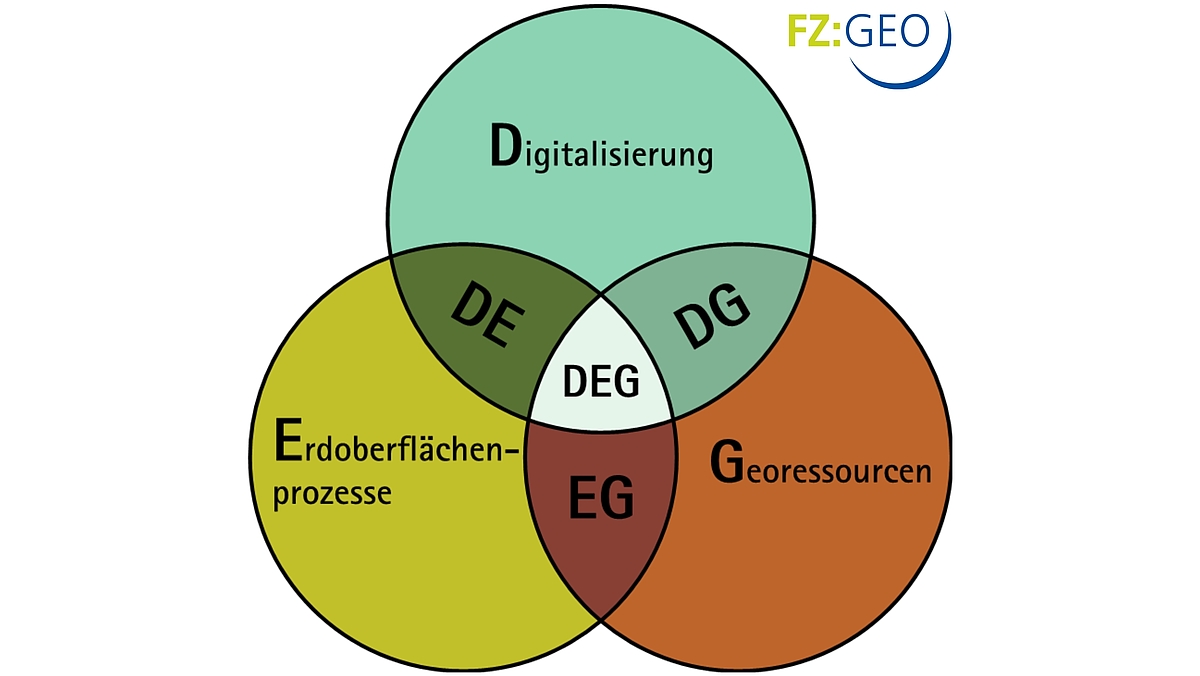
Use synergies
Given the expertise of the partners involved and the relevance of the topics for the research alliance, digitisation, earth surface processes and georesources have established themselves as research priorities for FZ:GEO. FZ:GEO is already active in these three key areas with several joint projects. However, there are also a number of cross-focal point projects that can be found in the DE, DG, EG and DEG synergy fields.
Digitisation
Times are changing, and so are the demands on science. Everything is becoming more and more digital and so science has to follow suit. The FZ:GEO is also looking at how data can be collected and analysed automatically and how it can be made accessible to the general public.
-
Digitisation: Our goals
With the rapid development of satellite-based remote sensing, it is possible to obtain geometric and radiometric data with a high temporal and spatial resolution for the exact measurement of the earth's surface and land cover, as well as information on mass distribution. In addition, advancing sensor and computer technology enables the in-situ recording of various conditions and parameters of all kinds of environmental and geo-related information (keyword sensor networks) and their changes over time (keyword monitoring). This is accompanied by modern developments in data processing methods, which lead to completely new possibilities, particularly in the area of automatic interpretation of sensor data (keyword: data mining). Modern technologies also offer the possibility of processing large, heterogeneous amounts of data (keyword big data).
The use and further development of these technologies and methods in the field of spatial data processing is the subject of current research at the participating FZ:GEO institutes. Measuring systems and associated platforms such as optical and thermal cameras, laser scanners, radar or hyperspectral scanners, airborne geophysical sensors, also with drones as carriers, are used to collect environmental data. Information that is partly implicit in images, laser scans or other geodata (such as trajectories and existing maps) is extracted from the data using machine learning methods - usually with the aim of recording and updating topographical information, for monitoring tasks in environmental sciences as well as in agriculture and forestry or to support disaster management. Deep learning techniques are used in various areas, for example for object recognition, but also for image categorisation and high-precision georeferencing. Finally, the availability of large, heterogeneous data, some of which is also available as continuous data streams, requires the use of processing frameworks that enable meaningful processing in the first place, such as the Hadoop ecosystem.
Geoscientific data and processes are characterised by the fact that they are highly complex and that the internal relationships are sometimes still unclear or uncertain. The cooperation between computer science and geosciences within the research centre offers excellent opportunities for both disciplines: the geoscientific data and issues are of a special nature and pose challenges from the point of view of data acquisition and processing. On the other hand, the technologies open up new approaches and insights for the geoscientific side. Collaboration is therefore not only essential but also highly innovative.
Earth surface processes
The study of Earth's surface processes, such as landslides or plate tectonics, allows us to better understand the natural processes of the Earth system and how they influence each other. We also learn to recognise how human activity intervenes in these processes and what consequences this can have.
-
Earth surface processes: Our goals
The surface of the earth is constantly changing. This is because complex interactions between the processes in the Earth's interior as well as the weathering and transport of rocks on the Earth's surface lead to these changes. The best-known natural deformations of landscapes and topography are, for example, tectonic uplift of mountains, incision of rivers and the transport of material into the oceans. But sudden events such as earthquakes, floods, landslides and landslides also change the earth's surface.
At the same time, the Earth's surface forms the interface at which the lithosphere, biosphere and atmosphere interact with each other. The processes at this interface are of immense importance for understanding the material cycles in the Earth system and for investigating the influence of climate fluctuations and human intervention on the dynamics of landscapes. The aim is to investigate the interaction of tectonic processes in the Earth's interior and surface processes. This allows natural landscape-forming processes to be identified and anthropogenic influences on the earth system to be separated. Finally, questions about the threat to human settlement areas from tectonically, climatically and anthropogenically induced landscape changes can be answered.
Georesources
In order to ensure the sustainable use of natural georesources such as deposits, soil and water, it is absolutely necessary to investigate and understand the exchange processes within and between the reservoirs of the upper continental crust.
-
Georesources: Our goals
One of the greatest challenges in the geosciences is understanding the complex exchange processes between the different reservoirs of the upper continental crust, including the critical zone. The critical zone is defined as the area of the Earth's upper crust that is formed by interaction with the atmosphere, hydrosphere, biosphere and lithosphere. This zone reacts particularly strongly to changes in endogenous (e.g. tectonic processes), exogenous (e.g. climate change) or anthropogenic parameters.
The research centre's focus on georesources will help to better quantify the exchange processes within and between the reservoirs and to assess the effects of external influences. The aim is to provide a basis for the evaluation and sustainable use of natural georesources - deposits, soil and water.
The exchange processes in and between the reservoirs have, for example, led to the selective accumulation of trace elements in certain areas of the earth's crust and to the formation of deposits. In the critical zone, in turn, exchange processes play an important role in weathering processes and bioactivity in soils. In all reservoirs, water plays a decisive role as a georesource and/or as a transport medium for elements. All three georesources - reservoirs, soil and water - are of great importance for satisfying the fundamental needs of mankind. Understanding the processes that lead to the formation of and threats to the three georesources is of crucial importance for humanity in terms of the sustainable management of the Earth system.
The three georesources - deposits, soil and water - are usually analysed separately in the individual scientific disciplines (e.g. geochemistry and geology, soil science and microbiology, hydrology and geophysics). However, these separate approaches are not suitable for understanding and predicting the complex behaviour of the exchange processes, particularly in the critical zone, in the overall context. The aim of the collaboration within the research focus is to bring together the traditional disciplines of geosciences in order to understand, for example, abiotic processes at depth (metal deposition, transport in hydrothermal systems, isotope distribution) and biogeochemical processes in the upper crustal levels (e.g. role of organisms and dead organic matter, metal transport in soils and sediments, pollutant input into groundwater and pollutant degradation).


